El Salvador
Republica de El Salvador is a country in Central America. The area was originally called by the People "Cuzhcatl" in Spanish "Cuzcatlan", which in Nahuatl means "the land of precious things." After the Spanish conquest, the land was baptized by Spanish conquistadors as "Provincia De Nuestro Senor Jesucristo El Salvador Del Mundo" (Province of Our Lord Jesus Christ, The Savior Of The World), now abbreviated as "Republica de El Salvador"
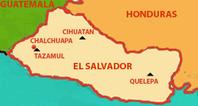
The country borders the Pacific Ocean between Guatemala and Honduras. With a population of approximately 5.8 million people, it is the most densely populated nation in Central America and is undergoing rapid industrialization.
In the early sixteenth century, the Spanish conquistadors ventured into ports to extend their dominion to the area that would be known as El Salvador. They were firmly resisted by the people and their remaining Mayan-speaking neighbors. Pedro de Alvarado, a lieutenant of Hernan Cortes, led the first effort by Spanish forces in June 1524. The people defeated the Spaniards and forced them to withdraw to Guatemala. Two subsequent expeditions took place, the first in 1525, followed by a smaller group in 1528,to bring the people under Spanish rule.